Birding Cadiz Province
  • Birding Cadiz Province
  • Birding Site Guide
  • Cadiz Birding Blog
  • Six of the best!
    • 1- Laguna de Medina
    • 2 - Tarifa
    • 3 - Sanlucar - Bonanza
    • 4 - Llanos de Libar
    • 5 - Bolonia Area
    • 6 - La Janda
  • Professional Bird Guides
  • Crossbill Guides & other information
  • Other Wildlife
  • Further Information
    • Information: Books, Information Centres & Leaflets
    • Trip Reports
    • Alcala de los Gazules
    • About Me
  • Contact

Borderlands!

20/7/2014

0 Comments

 
Picture
It's not just about birds.  No, honestly, it isn't!  Birds may be the prime reason for my interest in this area of Spain, but the region has plenty more to offer. The area to the south and south-east of the Arcos de la Frontera on the edge of the Alcornocales Natural Park doesn't include any outstanding sites or have any particular birds of interest.  However, it remains one of my favourite areas for its attractive scenery, historical and cultural interest.  Not that it doesn't also have birds to see ….    

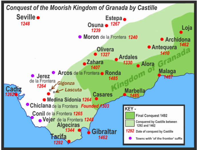
For nearly 250 years (1248-1492) this part of western Andalucia marked the boundary between Christian and Moorish Spain.  The most obvious reminder of this heritage are the string of place-names that share the self explanatory suffix 'de la Frontera'.  The centuries of rule by the Moors often goes unacknowledged although, if you're aware of Arabic etymology, it is traced by the place names.  If you know where to look, though, there's plenty in this area to remind the visitor of its complex history.

Picture
Picture
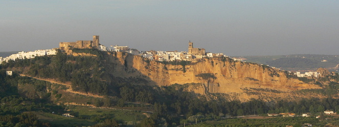
Arcos de los Frontera from the A 393
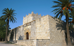
The gem here is old town of Arcos de la Frontera which stands majestically on a sandstone hill which has been dramatically sliced apart by the Rio Guadalete.  It's a pleasant place to stroll round and admire the architecture.  The view from the Balcon de Arcos off the Plaza del Cabildo at the top is breathtaking, but bettered from that to be had from the church tower in the square (check locally for opening times).  The castillo here is private, but was once the home of English bird artist W H Riddell who died here in 1946.  Riddell was also son-in-law of Walter Buck who wrote the pioneering work 'Wild Spain' with Abel Chapman.  Both had links to the sherry trade. If you want somewhere spectacular stay book a room with a terrace at El Convento just to the east of the plaza (the parador is more expensive).  It's worth searching out the small 'Moorish' garden which is just beyond this hotel since it's one of the few places locally where Spain's Moorish heritage is acknowledged.  It's a great place to take non-birding partners … but don't worry about withdrawal symptoms you get great views of Lesser Kestrel from the 'balcon' and, in season, migrating Black Kites, etc. 

Picture
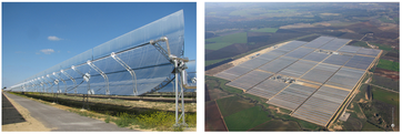
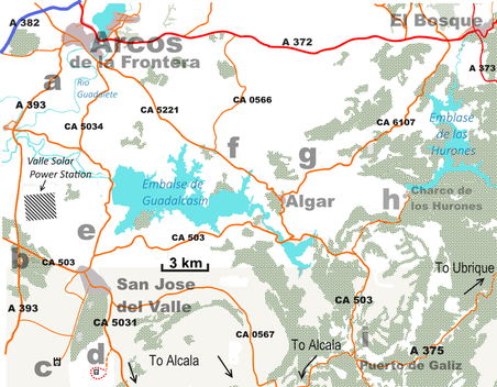
 For a view of the town (a) pull off a few kilometres south along the A 393.  Continuing south along the A 393 you soon pass the Valle Solar Power Station a solar thermal power station which became operational in January 2012. Unlike the familiar solar panels, huge fields of mirrored parabolic reflectors focus heat on oil filled pipes to generate electricity.  

PictureCastillo de Gigonza
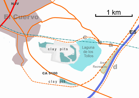
Pull off just south of the cross roads (b) with the CA 503 to explore some pleasant open cork woods (dhesa) where I've seen Hoopoe and heard Red-necked Nightjar.  If by now  any non-birding culture vultures are wilting by now, then some  further c4 km south divert to the left along narrow roads to the remarkable Castillo de Gigonza (c).  Now scarcely more than a fortified farmhouse with a watch tower – albeit a rather attractive one – this was once the site of the pre-Roman settlement of  Saguntia mentioned by Livy.  The town reached its zenith under the Visigoths and in the 7th century it was important enough to mint its own coins.  Under Muslim rule, it changed its name to Xisgonza, but standing on the border between Christian and Muslim Spain couldn't have done much for the long term prosperity of the town which fell into decline.   Not surprisingly there's scarcely anything left apart from the mediaeval castillo.  In the 19th century it briefly became famous for its medicinal sulphur springs.  There's not a lot to see, but its an atmospheric place and the tracks heading south towards Paterna could be tempting to explore ornithologically - those birds do keep sneaking in!

A little less than 5 km south-east from Gigonza there's a second intriguing memorial to times past, the ancient site of Lascuta (d).  Since both settlements were occupied  contemporaneously,  there must have once been a good road between them, but today only an increasingly decayed tracks link the two directly.  It'd make an interesting walk, but the easiest way to get there is to head back to San Jose and then back towards Alcala.  The CA 5031 towards Alcala, then as the road drops down and swings left (after c6 km south of the junction with the CA 0567) to pull off onto a reasonable gravel track (where a helpful Spanish/English information board stands). You can walk from here, but you can reduce the walk by a couple of km by driving further along the route until a very rough track heads up the hill to the obvious tower on the horizon. The Torre de Lascuta is a remarkable survival dating from the 2nd century BC when this area was fought over by the Romans and Carthaginian.   The settlement here dates from an even earlier epoch having its roots in the Chalcolithic Age ('Copper Age') of the third millennium BC. Of this ancient settlement very little, other than earthworks, remain. As you approach look out for a small Cattle Egret heronry in the valley below. Although deserted now, Lascuta has a unique place in Iberian history.  It was here that a famous bronze plaque, now in the Louvre, was found in 1840; dated to 189 BC it's the earliest example of a Latin text found in Iberia.  The views from here are excellent and it's well worth the walk. 
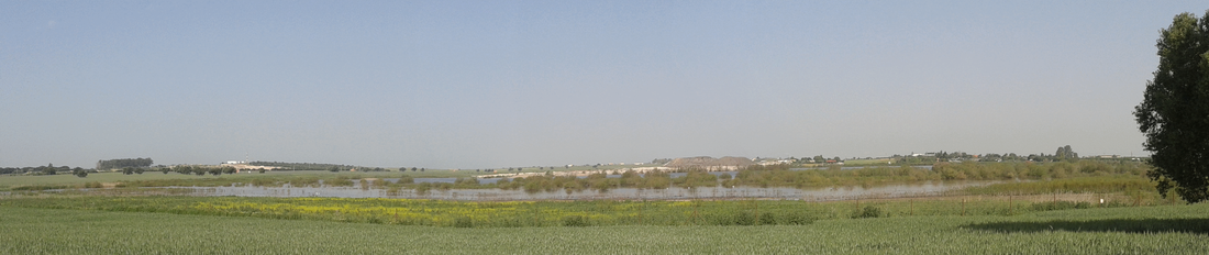
The CA  5034 (e) and CA 5221 (f) both provide alternative, arguably more attractive and certainly a quieter approach to Arcos.  Views across the Embalse de Guadalcasin towards the Alcornocales or Grazalema are stunning – in the UK it'd be a major tourist destination rather than a quiet backwater.  The views along the southern shore on the CA 503 aren't as good since you miss the mountains reflected in the water, Naturally the embalse attracts huge numbers of swifts during migration with Common, Pallid and Alpine in good numbers and it must be worth checking for a White-rumped although picking one out will be tricky.    
Picture
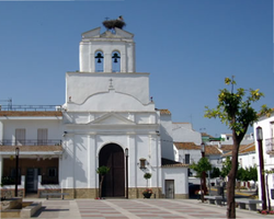
Algar Church - complete with stork's nest!
Unlike its neighbours, which all have narrow, twisting, labyrinthine roads, the small village of Algar is built on a strict rectilinear grid.  Unlike the traditional “pueblo blancos” which have Moorish origins, apart from the ruins of a small 13th century castle, Algar was created in the 18th century.  One Domingo López de Carvajal, a wealthy aristocrat, from El Puerto purchased land from Jerez de la Frontera municipality in 1757 and settled 90 paupers from Bornos, Ubrique, Benacoaz and Rosario  on the land in 1766.  Each was given a plough team and 25 acres of land and the village was gained Royal recognition in 1773. Evidently,  this was done in gratitude to the Virgin of Guadalupe whose intervention, during  a tropical storm on his way home from Mexico, Caravajal credited his survival!  Accordingly the  village church, built in 1762, is dedicated to Santa María de Guadalupe. From Algar the CA 6107 (g) runs north-west towards El Bosque and the Grazalema Natural Park. The road's not marked on many maps and warning signs still claim it's in bad condition, but it was repaired a few years back and is now a good, if little used, road to El Bosque. It's one of my favourite routes as it runs through attractive rolling dhesa with more excellent views of Grazalema.  

Picture
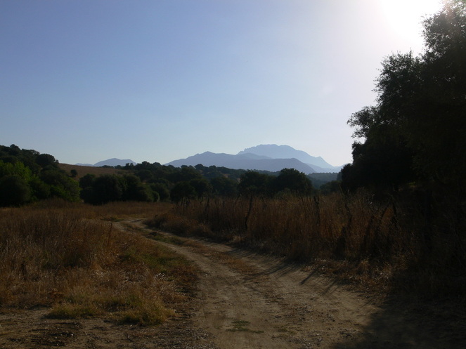
View towards Grazalema from near the CA 6107
Instead of taking the obvious route along main roads back to my base in Alcala de los Gazules from Arcos,  I often take the picaresque drive along the CA 503 between Algar and Puerto de Galiz. It's a much longer and slower route, but the scenery is terrific and, if there's room, it's worth stopping at the venta at Puerto de Galiz which has an excellent local reputation for good food (esp. game).   I passed the side turning signposted to the Presa los Hurones many times before I finally got round to exploring the road (h).  Shaded by an avenue tall eucalyptus trees, the road heads through an open landscape with the hills kept at bay some distance from the road, but gradually the trees and hills begin to crowd in.  It's this experience of finding your horizons gradually restricted that makes this drive feel more like an exploration.  After about 3 km trees close in round the road which soon drops down into the valley of the Rio Majaceite.  Here an abandoned 'recreation area' stands below a long straight bridge. The stream and bushes here probably deserve greater exploration than I've yet given them. The crags here often have Griffon Vultures too. Attractive though the valley may be, thus far it's just another pleasant drive.  What, for me at least, makes it something special nestles into the hillside below the dam another two kilometre further on.   Dropping down towards the bottom of the valley, you suddenly see before you a small hamlet that seems to combine the innocent charm of Trumpton and the  promise of Shangri La with a subtle hint of menace!  Built in the 1950s for the workers on the dam that towers above the village the twee 30 odd cottages, arranged in rows along the slope, look like something out of Lego-land.  In it's heyday there were over a hundred inhabitants here who had the use of their own community centre and swimming pool. Not surprisingly so since when few people had cars this was a pretty remote location. Fortunately, the small bar here remains open for a drink or simple snack. The centre piece, though, is the church whose bell tower overlooks the village.  Now that the population has shrunk to half a dozen or so,  these facilities are in various stages decay although the gardens are always neatly trimmed and maintained.  Charming though it is, it all looks just a little too neat, too controlled and, although decayed, too organised to be entirely comfortable; it would make a good location for a Spanish version of 'The Prisoner'.  From the top of the dam you have good views of both the settlement and the reservoir.  At the far end of the dam a flight of concrete steps take you through the woods to a concrete 'bunker' (Blackcap, Iberian Chiffchaff & Iberian Green Woodpecker are present).  This must once have been quite a viewpoint, but is now almost entirely screened by trees.  The overflow stream below the dam has Grey Wagtails and, according the owner of the bar, Otters – not entirely surprising perhaps since 'Charco de los Hurones' apparently means 'Pool of Ferrets'. Scan the skies for House and Crag Martins, 'Barn' and Red-rumped Swallows, Sparrowhawk, Common Kestrel, Booted and, with luck,  Bonelli's Eagle.  Those birds do insist in creeping in, but even for a non-birder this is a fascinating place to visit.
0 Comments

Jimena de la Frontera - route up to the TV masts (Lomas de Camara)

13/7/2014

3 Comments

 
PictureMap (left) showing location of road to TV masts and (right) route to the masts (c12 km)
Three difficulties have always put me off exploring this route in the past.  First is that to get to Jimena de la Frontera from Alcala requires a long roundabout route either down to the coast and back up again (90 km) or a more direct, but much slower route, through the mountains (55 km), both of which take about 70 minutes.  A more direct route (c40 km) from Alcala, following old drove-ways, was started under Franco, but only c5 km at the Alcala end was ever completed. This is, perhaps, just as well since locals tell me it was built by what was effectively a slave labour force made up of old Republican prisoners. The fact that, whatever route you pick, there are several attractive birding sites en route often means that I don't reach Jimena with much time to spare for exploration. Another, somewhat embarrassing problem, was that I could never remember how to find the route out of Jimena and along the track!  The final disincentive to explore is that even the most recent edition of Garcia & Paterson (Where to Watch Birds in South-west Spain) warn that the track is in a dire condition.  The start of the route certainly looked pretty bad when I looked some years ago and I rather assumed what followed must be worse, but, perhaps fortunately, I didn't have time to explore further as I wanted to go elsewhere to search for a site for Rufous Bushchat which I'd been told about.

This spring (2014) I was determined to find the right route at the very least and, hopefully, see how far along the track I could drive without worrying Liz unduly.  First problem – finding the route – wasn't so hard as I feared largely since I'd remembered to have a good look at Google Maps before | left home.  You just drive off the main road into Jimena, go straight across two roundabouts and then take the next left.  There's a clue in the name of the street, Calle Pasada de Alcala which, it turns out, is the far end of the drove road that runs east from Alcala.  If in doubt just follow signs to the local Guardia Civil office.  So having got to Jimena and on the right road, that was two problems dealt with!

At the bottom of the valley a narrow, straight bridge runs above the Rio Horzgarganta –  being somewhat grander than such a track would normally enjoy, I assume it was part of Franco's proposed new road.  It's worth pulling off here and watching for birds – the river has Grey Wagtails and Little Egrets, turtles bask on the rocks and I've seen snakes here.  Two paths run along the river into the woods and a circular route up to the caste above the town is possible (see map).  

With the first two “problems” - getting to Jimena and finding the road – resolved, it remained to be seen whether the Spanish authorities had done anything to resolve the third difficulty, the state of the road.   When I was last here just along the slope above the bridge the tarmac quickly degenerated into a dangerously pitted surface that threatened to “de-sump” the car of any incautious driver.  This time all was gleaming new tarmac, but how far did it extend?

Weaving my way up the narrow tarmac thread, at each turning I fully expected to see the sinuous, metalled road to give way to a rutted track long before I reached the TV masts (Lomas de Camara).  It never happened.  The whole route of c12 km, bar the last 200m, is now well tarmacked (and the first 2 km of the route can be seen on Google Street View if you want to check).   As it climbs, the road passes through a wide range of habitats – orange groves and small plots near the river, then rough pasture, bushy scrublands,  pine woodland, cistus maquis (matorral) and a few isolated areas of bare rock.  To be honest, birdwise there's probably not much to see here that can't be seen elsewhere – Bonelli's Warbler, Rock Bunting, Crested Tit, Firecrest, etc. There's always the chance of White-rumped Swift (although Jimena castle below is possibly better) amongst the swifts hawking along the ridge and, if you get it right, a stream of migrating raptors.  That said, having found Alpine Accentor in similar habitat and where they're not supposed to be on the top  of Picacho (only 16km to the NE), I wonder if they might haunt the rockier areas here in winter – I doubt whether many people have looked. Even if there are few birds, it does give you a great chance to see a cross-section of the attitudinal changes in vegetation.  There are a number of tracks and paths off this route that I've yet to explore - one that's worth noting is the good gravel track that peels off to the left c250m after you cross the bridge.  This meanders through attractive countryside, crosses the railwayline and then, via a ford, rejoins the A 405 (A 369) at the 24km marker just beyond Los Angeles (see Google Street View).  It would make a pleasant diversion en route to or from Marchenilla (the site I'd detoured to on my first visit for Rufous Bushchat).

So is the 12 km detour up to the TV masts worth it?  Very much so, for whatever the track may lack in exciting birds, is more than made up for by the stupendous views.  To the north-west Grazalema lies stretched out into the distance, to the south Gibraltar stands along the coast, to the west the wooded hills of the Alcornocales and beyond them Cadiz and Jerez.  So impressive are the views that you might expect the road to be clogged by tourists, but, unsignposted and little known, we found we had the place to ourselves.  If you're out in Spain with non-birdy friends or relatives and it's a good clear day then taking them here is a must - they'll be impressed by your 'local' knowledge!

3 Comments

Barbate Estuary - an update

13/7/2014

4 Comments

 
PictureBirding routes around Barbate Estuary
Barbate Estuary

With competition from Bahia de Cadiz (which has far more birds) and the Sanlucar area (home to more sought after species plus a better chance for close-up views), I don't explore the  Barbate estuary as often as I probably should.    It doesn't help that it's a little quicker to get to Bahia de Cadiz and, given I often visit Jerez, not that much further to Bonanza/Sanlucar.  However, since Bald Ibis began nesting at La Barca (near Vejer de la Frontera), the temptation to continue on down to Barbate – a mere 10 minutes by car – has grown.  One option is to walk along the river between La Barca and Barbate which is roughly 11 km one way (inc. 1.5 km along the road between La Barca and the footpath). The first c4 km near Barbate takes you along the tidal part of the river and an area with, in spring at least, plenty of pools and the last section of the path, shown by a green dotted line, has plenty of pools (a) along the final kilometre.  However be prepared for a c3 km stretch between these two areas which is less interesting.  I've not tried it yet, but according to the map there are two shorter loops of c4km (in red on the map) or 7 km (red and orange on the map) from Barbate. Either should be interesting (esp. in spring) although both miss out some potentially good habitat.  My interest in the estuary has increased further since my good friend LuisMi Garrido Padillo showed me where to access this sendero (footpath) and a more convenient place to scan the estuary (b) without the tiresome necessity of driving through the town.  Arriving from La Barca/Vejer go past the small industrial estate, then the petrol station and on to a roundabout at the start of Barbate where you head back towards the industrial estate turning off along a dirt track through the pines. (Note that turning left as you first pass this track is illegal and if caught may incur a fine). Follow this track turning right when you reach a building and then through a gateway and across a cattle grid to park under a couple of large eucalyptus trees. The footpath (see map) takes you along the edge of the estuary and up  the river past some large areas of mud and wet meadow.  This gives you plenty of opportunities to see a good variety of birds – I've had Osprey, Black-winged Stilt, Greenshank, Dunlin, Curlew Sandpiper, Kentish Plover, etc., Spoonbill, Flamingo,  Mediterranean Gull, Caspian Tern, Spanish Yellow Wagtail, Short-toed Lark, etc., but I've merely scratched the surface as yet.    

As there is little shade as you walk along the river or across the marshes, longer routes are not advisable at the height of the summer.  If you decide to walk all the way along the river I advise leaving your car (assuming you have one) at your starting point (either Barbate or La Barca) and catching the bus back.   Note that buses from Barbate to  La Barca start roughly two hours earlier in the morning than those from La Barca which makes this the better option (see – http://www.tgcomes.es/CONIL-VEJER-BARB-ZAHARA.pdf).  If you've time to kill at La Barca there are the Bald Ibis to watch (spring/summer) and a couple of excellent ventas for a snack or coffee.  

It can be worth stopping by the bridge (c) as you leave Barbate towards Zahara de los Atunes, but you have to pull off on to a track on the right some 450m beyond the bridge to do so.  Fortunately a path runs from the track to and under the bridge which avoids the tiresome need to walk along the busy road (there's no footpath).  I've found the river here good for checking gulls and terns (Caspian Tern often winter). The old salinas here tend to be fairly birdless although it may be worth taking a rough track (opposite the waterworks) across these salinas on the left another 200m further on which looks to be drivable for the first 600m until you reach a broad channel.  This track continues for another 500m along the channel.  One reason I've never investigated this route (apart from the birdlessness of the old salinas) is that less than a kilometre further on a rough track (d) on the left (just before you reach Restaurante Las Dunas) follows the same broad channel which you can easily check from the car.  After about 500m you reach private salinas and can go no further,but this section can be good for waders, Spoonbills, etc.  Another kilometre further on (and roughly opposite a third boardwalk down the the beach and marked by a roofed noticeboard) there's a second track (e).  A very rough track heads straight towards the shore of the estuary here, but instead take better alternative that swings to the left and then to the right round behind the nearby houses to reach the same point.   The marshes here can have good numbers of roosting gulls (inc. Audouin's and Slender-billed) plus all the expected waders.  For further details see my notes on the area.  
4 Comments

Laguna de los Tollos - Paradise lost … and regained?

2/7/2014

0 Comments

 
Picture
Although still shown on several road maps Laguna de los Tollos (or Tollon), near El Cuervo on the border between the provinces of Cadiz and Seville, has been largely ignored by birdwatchers visiting SW Spain.  It failed get a mention in the compendious “Important Bird areas in Europe” (1989) nor in any of the half a dozen or so birding site guides published in recent years. Yet until the mid-1970s it was one of the best sites to see many of the rare wetland species for which the area is famed. Breeding birds included White-headed-Duck, Purple Gallinule and Crested Coot.  It also regularly hosted some of the largest flocks of both Marbled Teal (c50 birds) and Ferruginous Duck (c100) in the area whilst it was a regular spot for Ruddy Shelduck.  Many waders and thousands of Flamingos regularly used it as a place to rest and feed.  This is hardly surprising as it was the third largest laguna in Andalucia and strategically placed on the avian commuting route between the Coto Donana and Laguna de Fuente de Piedra.  

So what happened?  Unfortunately, the impervious clay on which it rested and which allowed the shallow basin in which it nestled to fill with water was of a very particular kind.  This 'attapulgus' clay had some special characteristics which made it suitable for making 'Fuller's Earth' (valued in several industrial processes). So it was that, in 1976, a large clay-pit mining this mineral was opened next to the laguna.  It was to produce that absolutely vital material …. cat litter! What inevitably followed has been rightly described as an ‘ecological disaster’.   The deep excavations of the pit altered the hydrology of the basin reducing the water level in the laguna and reducing the persistence of  winter flooding. Eventually, the pits and the waste they produced swallowed up about a third of the original laguna.  Unfortunately, despite its rich avifauna, the laguna lacked the sort of legal protection for environmentally important sites that we'd take for granted these days.  With its  supply of water compromised things looked set to go into a terminal decline as the basin dried out (see -  https://www.youtube.com/watch?v=17Krs9rhPTo).  

Picture
Things began to  change when, in 1986, Laguna de los Tollos was optimistically included in the “Plan Especial de Protección del Medio Físico de la Provincia de Cádiz” and designated Special Area of Conservation.  Yet, at first, nothing much changed.  The clay-pit continued to be worked and the state of the laguna continued to deteriorate. Further damage was done by the building of the E5 motorway which further disrupted the hydrology plus the usual human disturbance and illegal dumping.  This state of affairs, though,  did not escape the notice of the local environmental activists who organised several protest marches and petitions highlighting the to the laguna (see – https://www.ecologistasenaccion.org/article27104.html).  In 1994, an internal report by the Environment Agency of the Andalusian government found that the quarry was causing serious ecological damage to the laguna. It also recommended that quarrying should stop. However, despite the obvious damage being done to an important wildlife site the mining company stubbornly continued to work the site. 

Fortunately, although commercial interests could ignore protests, they couldn't win in the courts and in 1998 they lost a crucial legal case.  This forced the mining consortium to abandon the site although they were not compelled to restore the habitat as many had hoped.  With the area now under the control of the Junta de Andalucia,  an ambitious plan to restore the habitat was launched. That much maligned organisation, the EU stumped up over €3 million and the Andalucian junta added nearly €5 million.  Work to solve the hydrological problems began in September 2010 and work to seal the old clay-pits should finish this year (2014). With the active engagement of local people the laguna has been fenced off, trees have been planted and an educational programme launched.  It's not been without difficulties and even as late as 2004, when the reserve's boundaries were settled, there were problems of damage from agriculture and illegal dumping.

PictureLaguna de los Tollos - May 2011
Having 'found' the laguna almost by accident in 2010 by discovering photos of Flamingos there on the internet, I was determined to have a look for myself. In May 2011 I managed to have a quick look at the laguna which, thanks to heavy winter rains, was still wet and hence full of birds. Not quite being sure of what to expect and with time pressing, mine was the briefest of visits. Subsequent visits have shown that this is now a site very much worth exploring.

On my first visit in early April this year (2014) I found the place alive with birds once more, but, significantly, the high water levels were no longer simply a matter of fortuitous winter rain, but of careful planned management.  The birds included Purple Gallinule, over 30 Black-necked Grebes, half a dozen Flamingos, similar numbers of Spoonbill, a good variety of ducks (Pochard, Red-crested Pochard, Gadwall, Shoveller & Mallard), a couple of dozen Whiskered and a few Gull-billed Terns, Avocets, Black-winged Stilts, Little Ringed Plovers, Collared Pratincoles and  in excess of 300 Coots (perhaps a hopeful sign that Crested Coot may soon return).  A subsequent visit in early May produced similar range of species plus several passing Curlew and Common Sandpipers and, best of all,  3-4 White-headed Ducks.  Some eight birds are present this summer and hopes are high that they may soon  breed once more.  Other birds present on the reserve this spring include Purple Heron, Little Bittern, Great-reed and Melodious Warblers.  Later in the season the tamarisks  here should also be worth checking for Olivaceous Warblers.   Black-winged Kite are present nearby and during passage almost anything might turn up.  I certainly found  much more of interest on my two visits to Laguna de los Tollos this year than I managed to find at Laguna de Medina, a much better known and more highly regarded site.  

PictureEducation work at Laguna de los Tollos
I was also delighted to meet up with some of the volunteers (from the Asociacion Ambiental Laguna de los Tollos) whose vision, hard work and dedication is beginning to transform the site.  Volunteers run educational programmes for local children and there was a real sense of pride in the laguna.  (see – www.lagunadelostollos.com & https://www.youtube.com/watch?v=fT-eK_MLll8).  The project is well supported by the people of nearby El Cuervo with one local venta owner telling the press "It's a very exciting and positive project.  Whenever people come here to work (on the restoration) or employment is given to cuerveños it's a good thing. We, like other bars and restaurants, can do well."Much remains to be done – when I was there a dog was lose on the reserve -  but there are plans to provide a hide and improve educational facilities.  So I left the place with huge optimism for the future. It is certainly a site that warrants visiting both for the birds and as a way of supporting this project.  El Cuervo may be a little out of the way, but it is en route between the famous Guadalquivir marshes near Trebujena and the less famous, but brilliant, the Lagunas de Espera. Then again in future you might not bother with Espera as you’ll get all the birds you want here!  here to edit.

PictureLaguna de los Tollos
The reserve is now well signposted off the N IV from the centre of El Cuervo.  The map gives you some idea of the best vantage points from which to scan for birds.  The track past the Area Recreativa allows panoramic, if distant views across the laguna, to scan for ducks and grebes.  Pulling over a little way along the good metalled road (a) to the left allows a slightly better view into the northern corner of the reserve.  Pull off near a shallow ford (b) to get good views of stilts and other waders feeding along the nearby shore.  A track a little further on on the left (c) allows you to explore another part of the laguna – the best area for avocets and stilts. Finally, a track running parallel to the motorway (d) often has Black-winged Kite and the tiny tunnel that runs under the motorway here has nesting Red-rumped Swallow!    

Picture
Laguna de los Tollos - May 2014
0 Comments

    About me ...

    Hi I'm John Cantelo. I've been birding seriously  since the 1960s when I met up with some like minded folks (all of us are still birding!) at Taunton's School in Southampton.  I have lived in Kent , where I taught History and Sociology, since the late 1970s. In that time I've served on the committees of both my local RSPB group and the county ornithological society (KOS).  I have also worked as a part-time field teacher for the RSPB at Dungeness.  Having retired I now spend as much time as possible in Alcala de los Gazules in SW Spain.   When I'm not birding I edit books for the Crossbill Guides series.

    Picture

    RSS Feed

    Categories

    All

    Archives

    February 2023
    November 2022
    October 2022
    September 2022
    August 2022
    June 2022
    May 2022
    March 2022
    February 2022
    October 2021
    June 2021
    May 2021
    April 2021
    November 2020
    July 2020
    June 2020
    March 2020
    October 2019
    August 2019
    July 2019
    June 2019
    May 2019
    March 2019
    January 2019
    December 2018
    November 2018
    September 2018
    August 2018
    July 2018
    June 2018
    September 2017
    May 2017
    March 2017
    February 2017
    January 2017
    December 2016
    November 2016
    October 2016
    September 2016
    August 2016
    June 2016
    May 2016
    April 2016
    March 2016
    February 2016
    November 2015
    October 2015
    September 2015
    July 2015
    May 2015
    April 2015
    March 2015
    October 2014
    September 2014
    August 2014
    July 2014
    June 2014
    May 2014
    April 2014
    March 2014
    February 2014
    June 2013
    May 2013
    March 2013
    December 2012
    July 2012
    June 2012
    February 2012
    December 2011
    October 2011
    September 2011
    July 2011
    June 2011
    May 2011
    April 2011
    March 2011
    February 2011

Powered by Create your own unique website with customizable templates.