i) Osuna Area
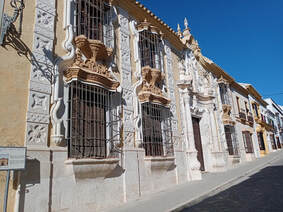
Osuna is one of my favourite Andalucian towns with a superb architectural heritage which alone would make it worth visiting but it's the presence of some of the last remaining "pseudo-steppe" in Andalucia and accordingly a population of bustards that brings me back time and time again.
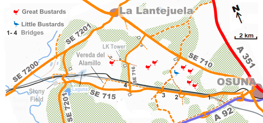
As usual I started by exploring the SE 715 from Osuna stopping at the first bridge over the unfinished AVE railway line. In the past I've had Great Bustard here but the bare arable field has long since been replaced by an olive grove. Happily, the second bridge (which also crosses the SE 715) came up trumps with three droves of Great Bustard in view (one to the right, a second roughly in front of me at the edge of an olive grove and a third larger group further off towards the SE 710 - see photos). I could also see half-hidden smaller birds that I suspected to be a couple of Little Bustards. They were too distant and partly obscured to absolutely discount the possibility that they were Mallards (which occur here and can look surprisingly bustard-like at extreme range) Hoping to get a better view of the largest drove I took the track over the third bridge (the connecting track from the second bridge is undrivable unless in a 4x4) to get a closer look. En route I found another small group of Great Bustards way off to my left. Arriving at the junction with the track from the second bridge the Little Bustards (as they proved to be) were flushed by farmworkers. Rather than just a couple of birds, there was a flock of 11 individuals which, fortunately, soon pitched down in a field near the track (see photo) hundred meters towards the SE 710. As I hadn't seen this species on my last couple of visits I was delighted to catch up with them (but was chagrined to discover others saw a flock of Black-bellied Sandgrouse in the same area a few days later).
Moving on to the fourth bridge, I briefly explored a few hundred metres along the gravel track running along the unfinished AVE line before heading for the track leading to the Lesser Kestrel Tower (at GPS 37.3076, -5.2314) which is an area where I've seen sandgrouse in the past. I failed in my quest but had a further two Great Bustards fly over (making my total for the day 56 birds) and a couple of Dartford Warblers. Less happily, I also saw further evidence of the encroachment of new olive groves on previous bustard/sandgrouse habitat (see photo).
I also managed to explore a couple of areas I'd not looked at before or hadn't done so for a long time. The first was the Vereda del Alamillo off the SE 715 which I'd passed many times and stopped at before but never fully explored. This time I walked c1 km down the track to and under the unfinished AVE railway line (although in doing so I discovered the track was perfectly drivable). En route I saw disappointingly little (House & Spanish Sparrows & Corn Bunting). Beyond the AVE line I had views across towards the tower constructed for Lesser Kestrels (in theory at least this track should link up with the track there but it is very degraded and suitable only for exploring on foot). I also confirmed that the track back towards the 4th bridge was still in good condition and decorated with 'official' signs' (implying public access). In the other direction the track seemed to be degraded as it ran uphill. This track eventually reaches the SE 7201 but exit is prevented by a chain (see photo). A track on the other side of the AVE track was in a far worse condition. I remain uncertain whether either track allows public access to or an overview of Laguna de los Ojuelos (although eBird reports suggest there is some sort of access is possibly by prior arrangement by the estate). Caution is advised as the estate raises fighting bulls ...
The second area I explored was along a track that's a westwards extension of the SE 715. This track soon becomes badly rutted and peters out after c500m just after it reaches a bare stony field. Black-bellied Sandgrouse have been seen in this area and the habitat (to my eye at least) looks ideal. Below at the foot of the hill lies the dry bed of the Arroyo Salado which also looks like suitable sandgrouse habitat. It may be possible to get a better view of this area by following the track immediately north of the AVE line where (after c1 km) another bridge crosses the unused railway (but not the active one).
If you want to see Black-bellied Sandgrouse and both bustards in Andalucia my advice, considering the continuing growth of olive plantations, is to go as soon as possible.
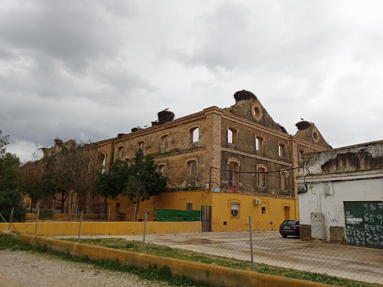
The Cordel de Jara is a narrow vein of wild habitat off the SE 7200 which threads its way trough a landscape dominated by intensive farming. It used to have a small observation tower but neglect seems to have taken its toll. The remaining information boards are so bleached by the sun that they are virtually illegible. Good to see that the pylon here has been modified to prevent large birds of prey perching on them, a major cause in mortality for Spanish Imperial Eagle, Bonelli's Eagle and other raptors. It's not a site you'd detour to see but it's a pleasant place to pause or have a picnic.
ii) Costa Ballena
It's a sad commentary on the current dire state of many wetlands in the province that this golf complex is (in 2021-2023 at least) the easiest place to find Red-knobbed Coot. It appears to favour the area where a bridge takes Calle Beethoven over a small canal linking the two 'lagunas' here.
iii) Humedal Cerro de la Ciguenas
Having 'discovered' this site online via GoogleEarth last autumn it was somewhere I was very keen to visit in person this February. Whilst I saw relatively few birds it proved to be a pleasant site with good potential for picking up interesting birds when conditions are suitable (i.e. wet). It's a couple of km NW of Los Palacios y Villafranca so is a very minor detour, particularly if heading along the NIV. To be honest, it has less to offer than Laguna la Mejorada (which is accessed off the same turning off the NIV) and still less than Humedal El Pantano on the other side of the town (best accessed off the E5/AP4). Yet if you turn off for the former then the extra 5 minutes to drive over to this site - if only out of curiosity - is very tempting and could pay dividends.
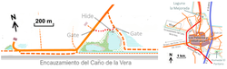
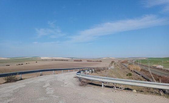
With a dozen or so White Stork nests (most already occupied) dotted around the site certainly lived up to part of its name which means "Hill of the White Storks Marsh" but the flat open landscape offered no hint of a hill as far as I could determine. The fences surrounding the reserve are punctuated by two daunting-looking gates both of which, happily, proved to be unlocked. The hide has a good view across what would be after a wet winter a small shallow laguna. It was dry when I visited but eBird reports suggest it could hold Whiskered Terns, Glossy Ibis, egrets, various waders, hirundines, etc. There was a small wet area behind the levee on my visit (see photo) which had a couple of Black-winged Stilts, 4-5 Avocets and a single Glossy Ibis. The broad Cano de la Vera nearby was dotted with shallow puddles (see photo) which could well attract Pratincoles, waders, hirundines, etc if still present in spring.
A noticeboard here gave some background about the site:
The Ecological Reserve "Humedal Cerro de las Cigüeñas" is declared with this figure of protection on the 19th December 2017.
It is a wetland located next to the Caño de la Vera, in the north-western part of the municipality of Los Palacios and Villafranca, in an old marsh area of the Guadalquivir river, which is currently highly modified by human activities. It has totally lost the tidal influence due to the multiple channels and dikes that have replaced the natural channels. Its waters essentially come from direct precipitation, surface runoff and artificial inputs through irrigation ditches and drainage from nearby cultivated areas. Despite this input, the wetland is seasonal, becoming completely dry during the summer period or maintaining very low water levels in the summer months, if rainfall and crop irrigation are scarce. Due to its characteristics and location to the nearby Coto Doñana marshes, this wetland is important for birds linked to wetlands.
It is included within a property owned by the City Council and has an extension of approximately 21.67 Ha. of which some 5.37 Ha. correspond to the floodable area. This, specifically, is not a natural wetland but arises from the closure and environmental restoration of an old uncontrolled landfill of urban solid waste in which the extraction of solid waste accumulated for years was carried out and sealed in 1997. Open for public use. (Translated with minor modifications by Google).
The Los Palacios y Villafranca council is also responsible for the hide and other work at Humedal El Pantano and must be congratulated not only for conserving these sites but also encouraging public access. I wish other local councils in Spain did half as much!
iv) Humedal El Pantano
This is one of three small wetlands around Los Palacios y Villafranca. Although the Laguna la Mejorada is the most well-known, in my experience Humedal El Pantano is much better with a greater variety of birds. On my short visit in February I had 65 Shoveler, 2 Gadwall, a Pintail, 5 Teal, 20+ Mallard, 15 Spoonbill, a Glossy Ibis and a Purple Gallinule but in spring it's far better. In the past I've found it to be the best site I know for seeing Little Bittern and Purple Heron but that depends on the water levels. Hopefully, as my photos indicate it should be in good condition in April and May.
The new noticeboards here give some interesting background to the site. The Google translation of the noticeboard (slightly amended) reads:
HISTORY AND RELEVANT INFORMATION
The Ecological Reserve "El Pantano" was declared on October 30, 2018. It has a flat morphology located in the zone of the transformed marsh, whose substratum is made up of Quaternary deposits. Ther artificial drainage and the Caño de la Vera accumulates water for long periods, generating detrital aquifers. Within the area you can differentiate three zones: the wet zone of about 14 hectares, a dried and cultivated zone of 21 hectares and another zone, also dried, separated from these two on the other side of the first arm of the Caño de la Vera occuping about 17 hectares. The characteristic vegetation of the area and its distribution are conditioned by two main factors, the duration of the flooding and the degree of salinity. The role played by these natural spaces in an environment as anthropic as this one is essential, especially as a refuge for birdlife. A large amount of zooplankton, water fleas, insects and various molluscs are found in the water. The abundance of the introduced Red Swamp Crayfish is remarkable. Among the vertebrates we find Common Frog, Ocellated Lizard and the water snake (presumably Viperine or Iberian Grass Snake - JC) , together with fish, including carp and eels. But the greatest value and attraction of these natural spaces is the abundance and diversity of waterfowl. Some species use these wetlands as a resting and feeding place during their migrations to Africa and others breed here. Respect the reserve and private property.
I wish other municipalities were as active in preserving wetland habitats and trying to make them accessible to visitors as Los Palacios y Villafranca! The contrast with my visit to Lantejuela is telling.
v) Casablanca
I've rarely visited this site so detouring to do so when en route to Seville and then back to the UK was an irresistible temptation. On some maps the area west of the railway line here is shown as a vast laguna understandably so on the rare occasions when an exceptional heavy winter rains flood the area. I've twice seen it in such a state when the shallow waters have been dotted with a multitude of of gulls, waders and Flamingos. Unfortunately, on both occasions I was going past on the train. Whilst poor winter rains seem to have made flooding less frequent, the poor vegetation here clearly shows that large areas remain soggy and unsuitable for arable farming. This was also confirmed by presence of almost 200 Cranes, 500+ White Storks and hundreds of Cattle Egret here on my recent visit. Surprisingly, GoogleEarth shows that several tracks that cross the area have designated road numbers indicating that they're accessible for the general public. Next time I visit I must give the area a whole day!
vi) Los Badalejos
I visited the area around Benalup several times to look for Little Bustard and was rewarded by twice finding small groups of this fast declining species. On my first visit I had a flock of 11 birds but a few days later had a group of 10 birds plus another 5 in the distance.
vii) El Portal
The old sugar processing factory at El Portal has one of the largest White Stork colonies (c50 nests) in the area. It's always worth a stop if only to hear them bill-clattering - a sound used to give voice to triffids in the 1963 film "The Day of the Triffids".
vi) La Janda
During my two week stay in Alcala de los Gazules I visited La Janda several times but, as I have before, found the site failed to live up fully to its high reputation. The best area was along the track from Benalup near the road up to the Embalse del Celemín where the soggy fields held Spoonbill, Glossy Ibis, Greenshank, Green Sandpiper, LRP and Ringed Plover.
However, I was delighted to be able to join the protest march for the restoration of part of the ancient laguna. This is a fantastic and well-thought through project that could transform the area for birders. My Spanish is shamefully poor but I was pleased to pick up in the speeches references to the pioneering efforts of Brits in discovering the ornithological delights of the Laguna de La Janda. See also - Cientos de personas marchan entre Barbate y Vejer para pedir que se recuperen los humedales de la Janda (lavozdelsur.es)
However, I was delighted to be able to join the protest march for the restoration of part of the ancient laguna. This is a fantastic and well-thought through project that could transform the area for birders. My Spanish is shamefully poor but I was pleased to pick up in the speeches references to the pioneering efforts of Brits in discovering the ornithological delights of the Laguna de La Janda. See also - Cientos de personas marchan entre Barbate y Vejer para pedir que se recuperen los humedales de la Janda (lavozdelsur.es)
viii) Puntas Secreta & Carnero
My guest's flight out of Gibraltar was delayed which meant we had time for a quick look at Puntas Secreta and Carnero. A stiff onshore SW wind was blowing so we had many passing Gannets, Kittiwakes and Balearic Shearwaters at Punta Secreta (although, to my surprise no Bonxies). The bay at Punta Carnero was more sheltered and attracted c100 Balearic Shearwaters.
ix) Palmones
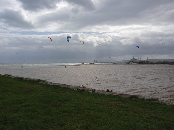
I stopped off at Palmones for lunch with my guest that week en route to Gibraltar airport. Wind surfing within the sandbar at Palmones (i.e. in the Nature Reserve) is banned but many surfers ignore this rule (in fairness signage is not good). Shortly after I took this photo the police arrived to tell the wind surfers to pack up but only once their friends had finished surfing. Happily, a few minutes later we met a British birder who'd just found a Lesser-crested Tern. With time pressing we'd only casually looked earlier through our binoculars so were pleased to have a look at the bird in his 'scope.

 RSS Feed
