I'm acutely aware that of all the areas described in my birding notes, I know the Bahia de Cadiz least well. This is partly because exploring them usually requires a drive along busy suburban roads and partly because other sites are more conveniently explored from my base in Alcala de los Gazules. Another consideration is that the most significant birding experience of the area (large numbers of waders) largely involves species familiar to UK birders. They do hold more exotic species (Audouin's Gull, Caspian Tern, Kentish Plover, etc) but these are just as easily found in the Bonanza area or Barbate (which also tend to have more exotic birds and, in the case of the former, offer better views of waders). I had intended to explore the area more fully but, with circumstances dictating that I've not been able to get out to Cadiz province for the last three years, such plans remain "on the back burner". Accordingly, I depend more than ever on correspondents and users of my site guide to update me on corrections/changes. Disappointingly, I never hear back from most of those who use my notes presumably (or should that be hopefully?) because they don't encounter any problems with them. Thankfully a handful are regular correspondents one of whom, Alf King, has kindly pointed out some errors in my description of San Fernando marshes.
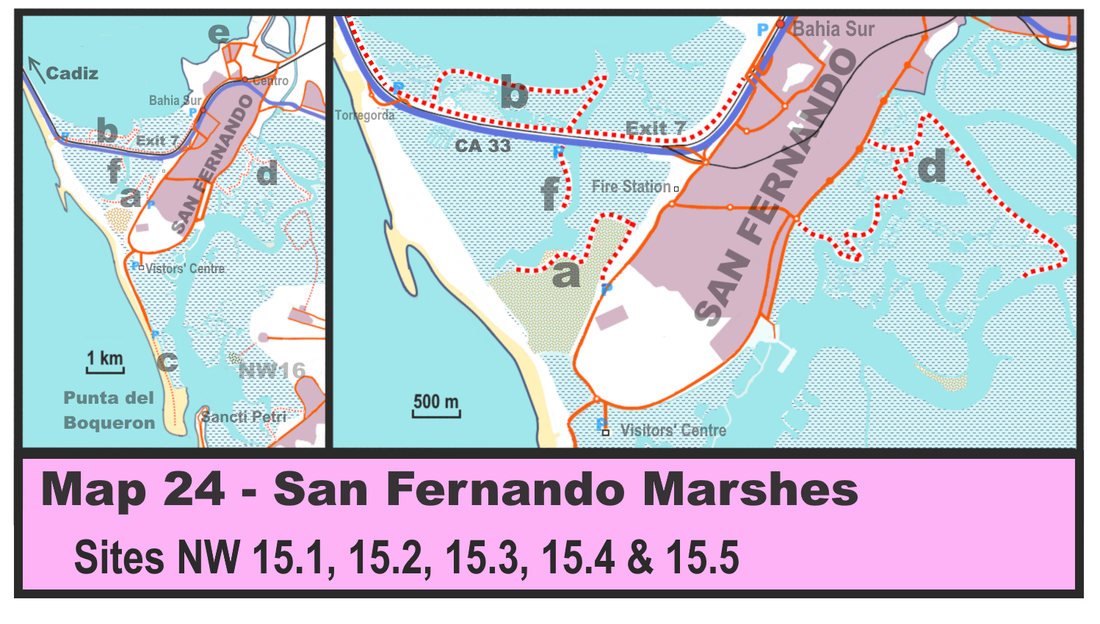
Armed with this new information I have fully revised my notes and redrawn my map of the area (see above). Despite several sources (inc Wikiloc on GoogleEarth) indicating that the sendero at the Tres Amigos saltpans offered an 8 km circular route, this is not the case and visitors have to content themselves with a 3 km route (a) that loops around part of the site. In the process of revision I also noticed that the northern 'arm' of the Tres Amigos sendero appears to be accessible off the CA 33 (f). Google Street View shows cars pulled off here by derelict buildings by the 6 km marker but great caution is needed if turning off and back on here (only possible as you head towards San Fernando) as this is a very busy road. Not having explored it personally I'm unsure about access details so use at your own risk! I have also revised access details in general. Alf also tells me that the board walk along Punta del Boqueron (c) was badly damaged by tidal surges in early 2018 so access might be limited until it is repaired.
Addendum - on reading the above the ever helpful Alf King reminds me that the Visitors' Centre here has maps and leaflets about the area including one that shows the 'northern arm' of the Tres Amigos sendero as being legitimately accessible. He also tells me that the principal interest here isn’t ornithological but historical as the site has a late 13th century flour mill powered by the rising and falling tides. This was one of a network of hundreds of such mills stretching from Faro to Cadiz Bay and they were the main means of milling in that period.
Addendum - on reading the above the ever helpful Alf King reminds me that the Visitors' Centre here has maps and leaflets about the area including one that shows the 'northern arm' of the Tres Amigos sendero as being legitimately accessible. He also tells me that the principal interest here isn’t ornithological but historical as the site has a late 13th century flour mill powered by the rising and falling tides. This was one of a network of hundreds of such mills stretching from Faro to Cadiz Bay and they were the main means of milling in that period.
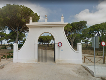 'Puerta de Carboneros'
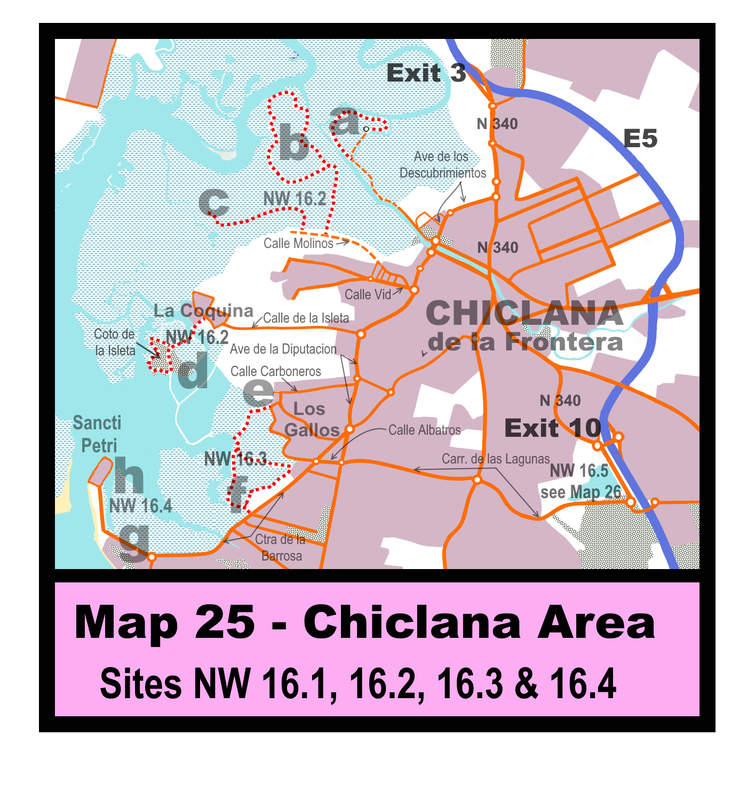
 Having revised access to and details of NW 15, I also took the opportunity to revise my notes on the following site (NW 16). Little needed to be changed for NW 16.1, 16.3 & 16.4 but NW 16.2 was more tricky. First, though, those curious about what facilities are available at NW16.1 (particularly if you have some Spanish) might like to view this short video on the site (see https://www.youtube.com/watch?v=tm6MuJjCSPo).
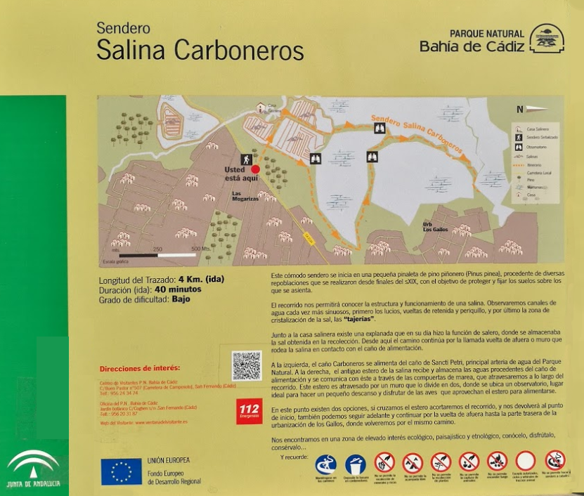
On paper at least, NW 16.2 has good potential but access is problematical and I've not been able to check in person. Only one of the three suggested walks (Collejon del Mollino) is featured in the “300 senderos” booklet (https://issuu.com/cadizturismo/docs/300senderoscadiz/1?ff=true&e=3220287/1858612), the others being derived from a search of GoogleEarth. This suggest that access may not be straight forward. The 6 km walk through Salina de San Ramón y la Pastorita (b) takes you to the main channel and should allow good views across of the centre of the marshes. In all likelihood you’ll see few birds you won’t find at the more convenient NW 16.1 (which also has the advantage of offering refreshment and a panorama across the salinas from a covered viewpoint) but may interest the adventurous. About 500m further along the Calle Molinos another sendero, Collejon del Molino (c) - Walk 167 in the “300 senderos" booklet - also promises a route into the salinas (but is not shown on GoogleEarth). The wild card here is the Coto de la Isleta, a wooded island in the centre of the marshes, which should be an interesting destination but access is open to doubt. “Wikiloc” shows a sendero linking it to the village of La Coquina (d). However, a close look at GoogleEarth seems to show that the causeway connecting the island to the village has been breached and therefore that the island is inaccessible. I've left it in just in case foot bridges have or may yet be constructed. Even so it may still be worth exploring this area as some roads/tracks may offer good views over the marshes/salinas. Another option for the adventurous....
I've tried to drive through Los Gallos to (e) several times but the maze of narrow one-way streets in the urbanisation are such that I've got lost every time! I've revised my directions to take what seems a longer, but should be quicker route (as you're less likely to get lost!), via the suitably named Calle Carboneres, which involves only two turns and no one way routes! Essentially, you head north on the Avenida de la Diputacion and when you've negotiated roundabout betwixt the Mercadona and Lidl supermarkets the left-hand turning into Calle Carbonares is another 650 m (although it may be easier to continue a further 150m to a roundabout and return the way you came to make it an easier right-hand turn). Follow this road almost until its end (c1 km) and then turn left and shortly afterwards right into the Calle Codorniz where you can pull off onto rough ground and explore the sendero. Access via (f) is much less complicated since the white 'Puerta de Carboneros' makes the start of the sendero obvious whilst parking in a nearby side road is convenient. You can even reach this starting point by bus (routes L8 & L11).
Alf has also pointed out that many of the information boards that dot many sites listed in my guide now boast QR codes which helpfully allow you to download information onto your mobile phone.

 RSS Feed
